
Dynamic Maps For Emergency Preparedness

"The need for accurate maps of indoor environments is critical in schools and communities for first-responders’ navigation and tracking systems. When responding to emergencies, saving time and increasing the speed of determining the layouts of structures enables first responders to make informed decisions before entering a building"
Kathryn Coulte - Science and Technology at the U.S. Department of Homeland Security.
Navigating Preparedness
Your Digital Preparedness Plan
See how a SS3D digital preparedness plan can support emergency services at your location.
Included Features
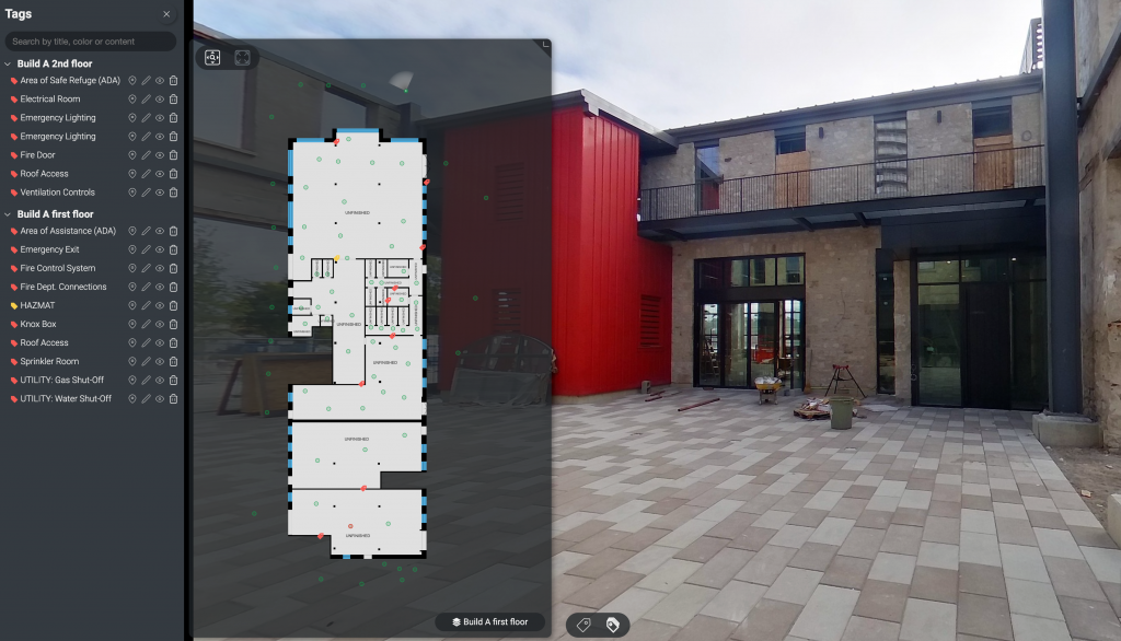
Standard Emergency Tagging :
- Alarm Control
- Fire Control
- Utility Location
- Knox Box
- Access & Egress
- FDC
- Roof Access
- HAZMAT Areas
Our standard SS3D emergency mapping system includes color organized tags of all the most important emergency assets on your site. This includes Utility Shut-Offs, Fire Dept. Connections, Knox Boxes, HAZMAT areas, Fire Control Systems, Access and Egress, as well as Alarm Control systems. Each map also includes embedded 360° imagery which allows first responders to be able to visualize the permanent layout of each of your venues’ spaces.
Your Lifeline in an Emergency
When every second counts, first responders need a trusted ally to navigate through chaos and uncertainty. SearchScape3D is the groundbreaking emergency mapping system designed to be their guiding light in the most critical moments.
Our cutting-edge technology revolutionizes the way we approach emergency response. With precision and speed, SearchScape3D swiftly identifies and tags vital utilities, such as water, gas, and electricity, and delivers a comprehensive view of your surroundings when you need it most.
What sets SearchScape3D apart is its ability to provide first responders with updated, three-dimensional visual images of the school, ensuring they have unparalleled situational awareness. This powerful tool empowers them to make quick and informed decisions, ultimately saving lives.
Key Features:
🌐 Utility Tagging: Instantly locate and visualize essential utilities.
🏫 School Mapping: Accurate 3D representations of the school’s layout.
🔦 Offline Insights: Our technology is available offline for Emergency kits, district offices, admin go bags, and for copies with local emergency agencies.
🚀 Rapid Response: Faster, more effective emergency management.
In times of crisis, SearchScape3D is your reliable partner, bringing clarity and direction to the chaos. Trust in our technology to make a difference when it matters most. Protecting lives, one accurate map at a time.
Captures
0
+
Locations
0
+